
Our excursion of Saturday 25 March 2017 takes us to Mahairas forest, further up from the village of Lythrodontas. This route in the Mahairas forest is part of the E4 footpath, the European Path that goes from Cyprus to Portugal. It is therefore well signposted and was chosen to show the best of the Cyprus mountains, so is extremely beautiful. It is linear and 14 km long from its start, the Monastery of Prophitis Elias (Prophet Elijah) to the Kionia picnic site and back, with 500 metres of ascent. Not surprisingly, it is graded 3+, or very difficult, so more of a challenge than most of our walks. The duration of the hike is about five hours, including stops, so you are urged to carry plenty of water.
The hike starts at 10:45 am. Ian is leading the hike, which will go ahead even in light rain; if you need to, call 96852722.
Strollers who prefer to walk only the uphill leg, are advised to alert Ian or Xenophon latest 1 week in advance. The proposed arrangement will be to bring such Strollers into contact with each other, so that you will then define a plan whereby you drive first to Kionia, park half of your cars there, then drive in the other half of your cars to the walk start. Note you will need to depart from Nicosia much earlier, to be able to be at Prophitis Elias by 10:45. Note also that the uphill leg is ‘easier’ than the downhill leg.
The path starts at the Monastery of Prophitis Elias, and is basically all uphill for the 7 km, until it reaches Kionia. The path follows good signs for E4 behind the monastery. After about 1 km it joins a Forestry road, but only for about 200 metres. Then, where there is a bench above the road, we take the small footpath leading up towards the ridge. At 4km there will be a clearing in the trees where cars turn round from a dirt road leading down. This would be a convenient point for less confident Strollers to turn back and return to start, as the path gets steeper from here, but if they do they will miss out because the mountain scenery along the next 3 km is truly outstanding. From the clearing there will be a lot more tree cover, providing welcome shade.
The Kionia picnic site at the top has shade, water, tables and toilets, and is on a good road leading to Kapedes and so back to Nicosia (allowing some people to get home early by arranging for a friend to meet them there with a car). Those able and willing to continue (all of us, naturally) will walk back downhill to the monastery, from where we will drive to the village of Lythrodontas to have a well-deserved meal at a taverna. To facilitate arrangements, for your better service, you are required to pre-register, if you are joining us for lunch. To do so, please sms the walk leader or e-mail Xenophon by end Thursday. No need to register if you are not dining.
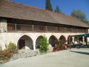
Interestingly, the Prophitis Elias monastery played a part in the Second World War. The monks had left long before, and it was lived in by a retired forester. During the war, when it seemed that the Germans might overrun the island as they did in Crete, plans were laid to create a resistance movement in the event of invasion, run by British people with good knowledge of the mountains, mainly from the Forestry Department. It was called Force 133 and was organised by Special Operations Executive in Cairo. They used Prophitis Elias to hide food, clothing, ammunition and bomb-making equipment. Fortunately, there was no invasion. No doubt the path we will take was intended to be a supply route for the British mountain hideouts. Probably it was created by monks a thousand years ago over the mountains to the main Mahairas Monastery.
You have the choice of meeting the group at the hike start, or meet at the designated meeting point in Nicosia. In either case, you need to carry copy of this set of instructions. Meeting Point in Nicosia is the Handicrafts Centre (Kentro Heirotechnias) on Athalassas Avenue at 9.30, to leave at 9.45 (English time, i.e. no delays!).
To get to the walk start:
Get to the main junction between Leoforos Lemesou/ Limassol Avenue and Leoforos Athalassas. Zero your odometer at this junction. Drive along the Nicosia-Limassol motorway, heading towards Larnaca. At the 15.2 km reading the motorway splits in two: do not go straight (towards Limassol), take the left turn, towards Larnaca. At the 16.7 km reading (very soon after the motorway divides) take exit number 8 to the left, signposted to Lythrodontas. At the 17.4 km reading you reach a T-junction: go left. Slow down, drive carefully for the next 200 m. At the 17.6 km reading turn right into the E103 road (do not be misled, there is a sign also indicating ‘Nicosia’ at this same turn). At the 18.9 km reading you enter the village of Agia Varvara. At the 25.2 km reading you enter the village of Mathiatis. At the 28.3 km reading you enter the village of Lythrodontas. Drive along the main road crossing the village. At the 30.0 km reading you pass a Mas supermarket on your right and the road bends left. Continue through the village. At 31 km the road forks: go right, following the sign to Mahairas Monastery, but at 32 km look out for a sign to Prophitis Elias Monastery and turn left on to a dirt road (the road is bumpy at places). At 35 km the road divides three ways with no signposts: take the middle road, i.e. straight on. At 37 km we reach our destination, Prophitis Elias Monastery, which has plenty of parking spaces. The walk will start at 10.45.
How to get to the meeting point for the car trip, coming from the Hilton hotel area:
Get yourself on Makarios Avenue, heading out of town and set your odometer to zero as you drive past the Nicosia Hilton hotel. At the 0.1 km reading you reach traffic lights (with the Apoel club building on your right), go straight. At the 0.5 km reading you reach another set of traffic lights, go straight. Driving along, you pass a few more traffic lights, staying on this main road (named Leoforos Lemesou/ Limassol Avenue). At the 2.1 km reading, you reach a principal set of traffic lights. Set your odometer to zero again and turn right here. You are now in Leoforos Athalassas, a very busy avenue. At the 0.2 km reading you see a large empty space on your right and the Handicrafts Centre (a single-storey building) on your left. Park in the parking area. We meet here. The Handicrafts Centre is next to the church of St. Barnabas.
How to get to the meeting point for the car trip, coming from the Presidential Palace area:
Get to the round-about next to the Presidential Palace. From downtown Nicosia you reach this along the Kyriakou Matsi avenue or along the D. Severi avenue. Set your odometer to zero on the round-about and drive along the principal road towards Strovolos. At the 0.3 km reading you reach traffic lights. Go straight. At the 0.6 km reading you reach a 2nd set of traffic lights. Set your odometer to zero again and turn left. You are now in Leoforos Athalassas, a very busy avenue full of shops. At the 2.6 km reading you see a large empty space on your left and the Handicrafts Centre (a single-storey building) on your right. Park here.
Google Maps: Here is a map for those coming from the Hilton area to the meeting place for the car trip http://tiny-url.org/RWPji5wr
Google Maps: Here is a map for those coming from the Presidential Palace area to the meeting place for the car trip http://tiny-url.org/hvLSn8Nw
Disclaimer: If you attend a Cyprus Strollers walk you do so entirely at your own risk. The Cyprus Strollers is a social club and neither the organizers nor the leader of the walk are responsible for the health and safety of those taking part.
